Tracks and areas
Link a GPX, GeoJSON, KML, or TCX file from a note and the map draws it. A track file can also be a result of its own in a Base — a Base is an Obsidian file that collects notes and files you filter for, and shows them as a table or a map. A track file linked from a note is drawn in that note’s marker colour.
Draw a route on an existing Base map
Section titled “Draw a route on an existing Base map”Use a plain link, with no !, to put the route on the Base map without adding a
second map to the note. The coords line below is frontmatter: the properties
block at the top of a note.
---coords: 30.215709,120.130799---
[[track.gpx]]
When the Base includes this note, its map draws the route. A link in frontmatter works the same way:
track: '[[track.gpx]]'Use an embed only when you want a second route map inside the note:
![[track.gpx]]| Syntax | Base or Around map | Inline route map in the note |
|---|---|---|
[[track.gpx]] |
Draws the route | No |
track: "[[track.gpx]]" |
Draws the route | No |
![[track.gpx]] |
Draws the route | Yes |
Body links, embeds, and file links in frontmatter are read separately and then de-duplicated. Only an actual embed creates the inline map.
Route markers
Section titled “Route markers”Routes get distinct start and end markers, direction arrows, and named waypoints. Show track markers turns these extras off.
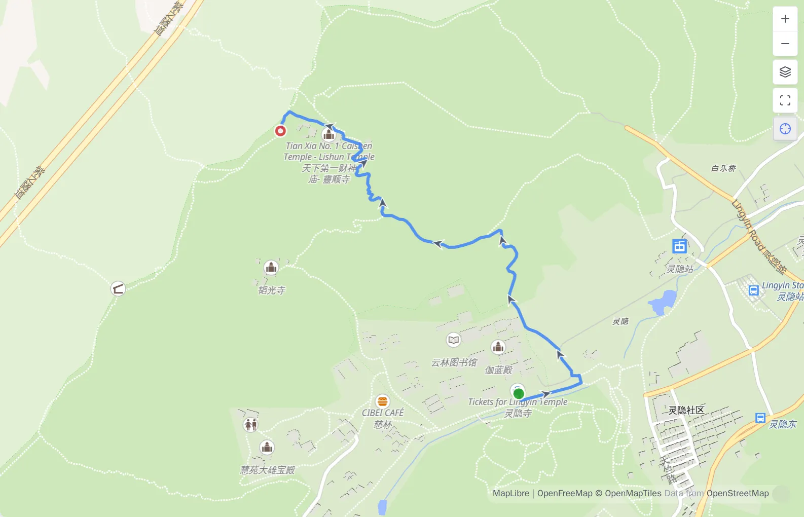
Pointing at a route on a Base map
Section titled “Pointing at a route on a Base map”Hovering a route opens the note’s own popup — the same card its pin opens — with one row added for the thing under the pointer. On a phone, tap the route instead; the same popup opens, with the same row.
- A route adds that file’s distance, climb and elapsed time, labelled with the file’s own name. A note carrying a morning hike and an afternoon ride reports each file on its own. The two are not added together.
- A named waypoint adds its name instead. Show track markers turns that off along with the markers themselves.
- An area adds nothing. An area has no distance, climb, or time to report.
Only the figures a file recorded appear: a GPX with no elevations shows distance
and time, one with no timestamps shows distance and climb. The rest — descent,
elevation range, moving time, pace, and the elevation profile, a chart of height
along the route — stays under an inline ![[track.gpx]].
If a note’s displayed properties are all empty, the built-in map raises no popup for it at all, so there is no popup to add a row to. That is its own rule for pins, and it applies here unchanged.
GeoJSON and KML areas
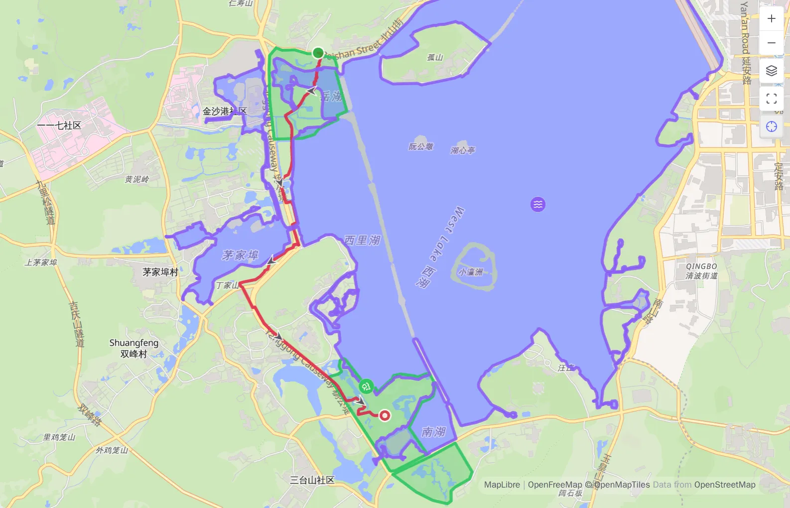
Section titled “GeoJSON and KML areas”GeoJSON and KML can hold an area rather than a route. An area is filled in the owning note’s colour and outlined at the same width, and a hole stays a hole.
An area gets no direction arrows or start/end markers and adds nothing to the statistics below an inline map. It is also the last thing a click reaches: a marker, waypoint, or photo inside an area keeps its own click.
Inline route maps and statistics
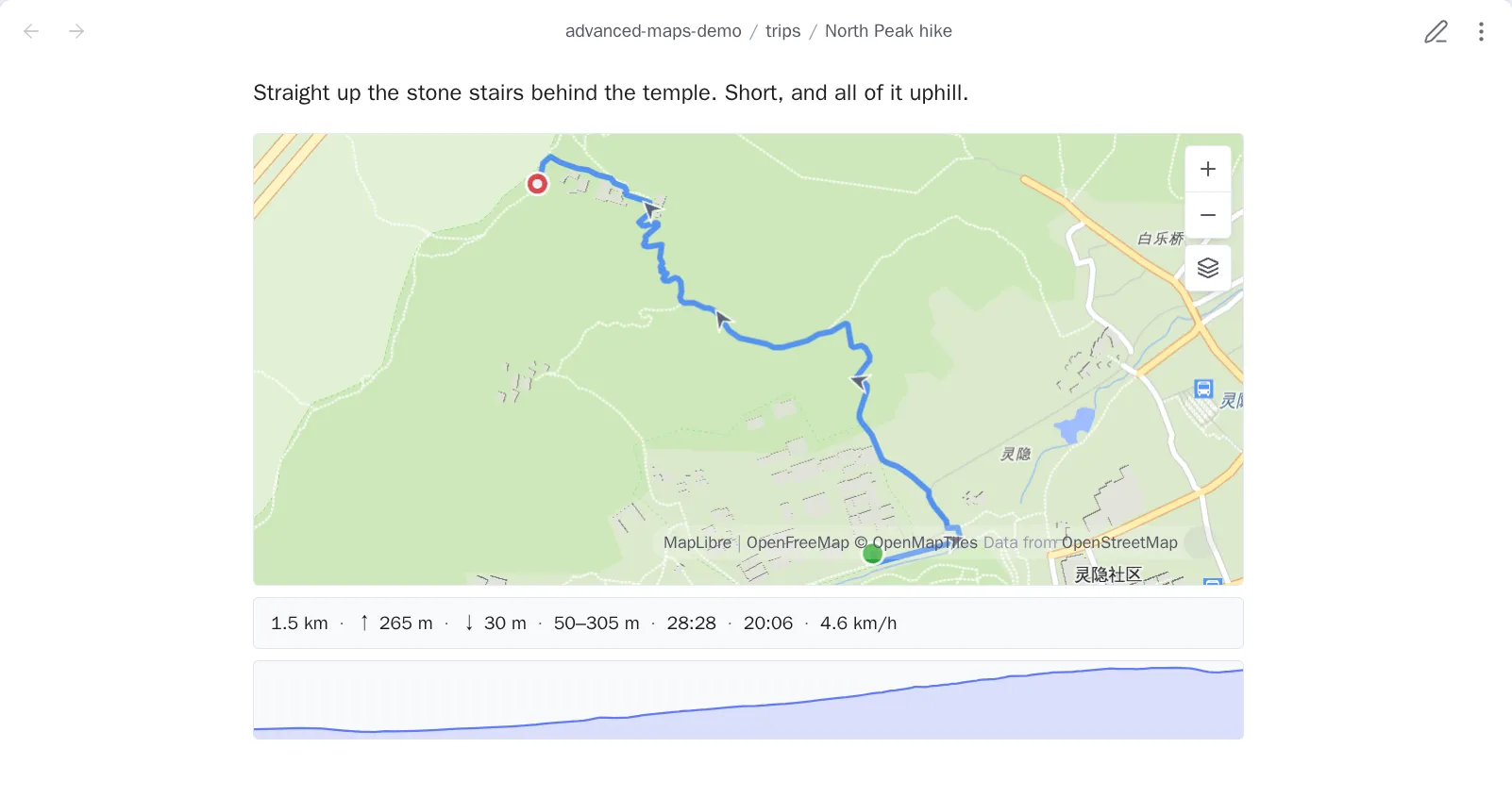
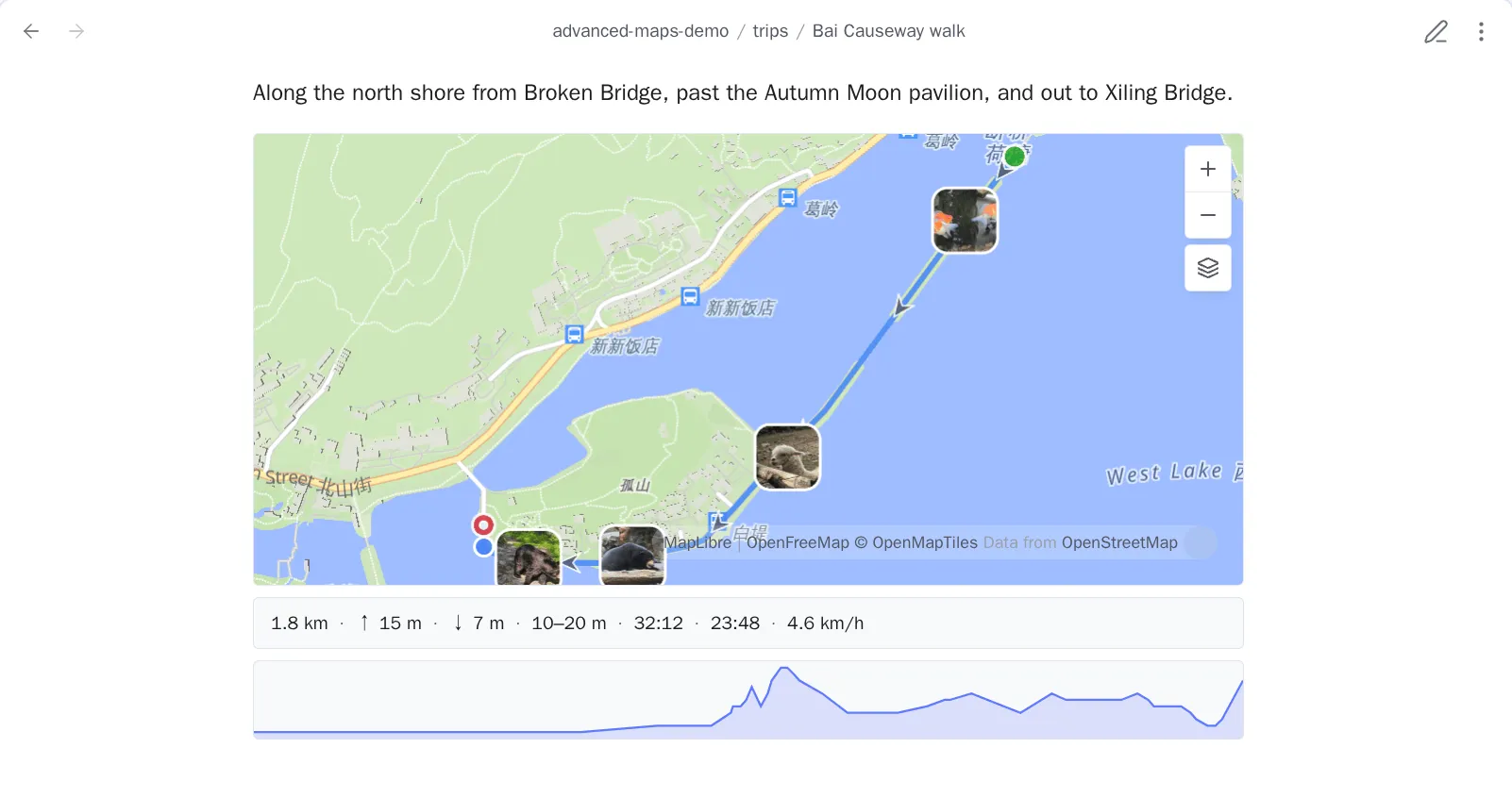
Section titled “Inline route maps and statistics”An inline ![[track.gpx]] is a live map with distance, ascent and descent,
elevation range, elapsed and moving time, pace, and an elevation profile.
Missing source data is omitted instead of shown as zero. Hovering the profile
moves a cursor along the route, and hovering the route moves the profile’s
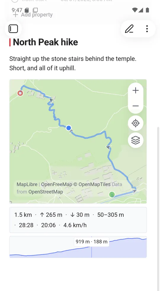
readout. On a phone both directions answer to a tap: tap the profile and the
cursor moves along the route, tap the route and the profile’s readout follows.
The reading stays where you put it until you tap somewhere else, since there is
no pointer to leave.
Ascent ignores changes under 5 m, so GPS drift is not counted. Moving time counts speeds above 0.9 km/h, so slow walking and stairs still count.
Inline route maps under settings → Tracks decides whether any of this
happens. With it off, ![[track.gpx]] shows the file embed Obsidian makes on
its own. A note already on screen shows that after you open it again.
An inline track map also draws geotagged photos linked from its host note. Route statistics continue to describe the route alone.
Statistics a Base can sort on
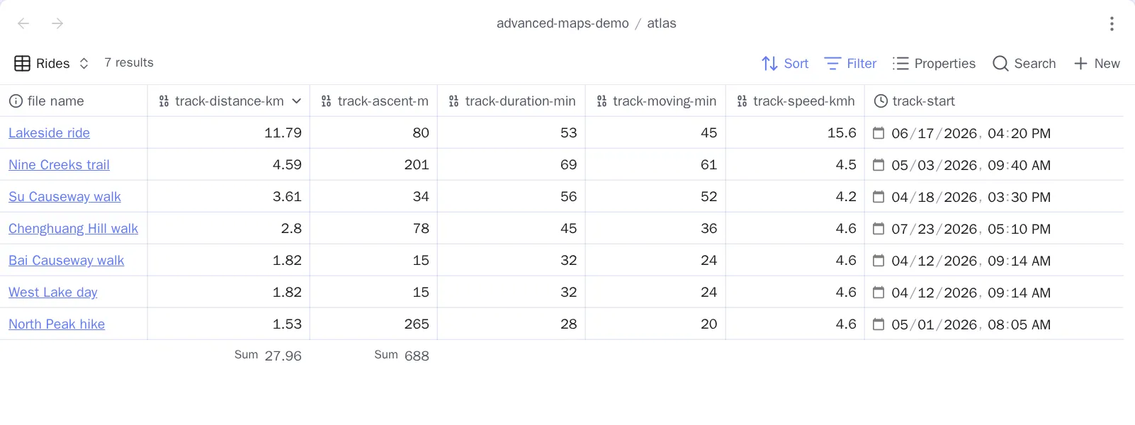
Section titled “Statistics a Base can sort on”Those numbers live in the embed, where no filter can reach them. Write track statistics to properties measures the track files the current note links and writes the figures into the note’s own frontmatter, as numbers:
track-distance-km: 13.62track-ascent-m: 512track-descent-m: 499track-lowest-m: 12track-highest-m: 1850track-duration-min: 161track-moving-min: 148track-speed-kmh: 5.5track-start: 2024-05-01T09:30| Property | Unit | Source |
|---|---|---|
track-distance-km |
kilometres, 2 decimals | Every route segment, summed |
track-ascent-m |
metres | Climb past the 5 m noise threshold |
track-descent-m |
metres | The same, downhill |
track-lowest-m |
metres | Lowest elevation anywhere in the file |
track-highest-m |
metres | Highest |
track-duration-min |
minutes | Last timestamp minus first |
track-moving-min |
minutes | Intervals above 0.9 km/h |
track-speed-kmh |
kilometres per hour, 1 decimal | Distance over moving time |
track-start |
local datetime, to the minute | Earliest timestamp, in this device’s zone |
The unit is in the name because a bare number in frontmatter says nothing about
what it measures. Now a Base can sort a column of rides by distance, filter to
track-ascent-m > 800, or total a month. track-start stops at the minute for
the same reason: that is the shape Obsidian types as a Datetime property,
and with seconds on the end it would be plain text.
Three things worth knowing:
- It runs when you run it. Editing a track file afterwards does not rewrite the notes that link it — run the command again.
- A note is one row. If a note links two track files, one set of properties
describes both. Distance, climb and moving time add up;
track-duration-minis first stamp to last, so it spans the gap between a morning hike and an afternoon ride; and pace is the total distance over the total moving time, so pairing a timed GPX with an untimed GeoJSON reads faster than either ride was. One file holding those two segments reports the same figures. - It owns the names it is currently writing, and nothing else. Anything outside them is never read, written, or removed — and if a name would collide with the coordinate or place property, or two figures would share one name, the command refuses instead of overwriting anything.
Choosing which figures are written
Section titled “Choosing which figures are written”Settings → Tracks → Track properties gives each figure one row: the name it is written under, and a switch beside it, all nine on to begin with. Turn one off and the command stops reaching it: nothing is written for it, and a property already in a note under its name is left exactly where it is. Turning a figure off decides the next write; it does not delete what you already have. A walking log that switches off seven figures writes distance and start time only.
With every figure switched off there is nothing to write, and the command says so rather than reporting that it wrote nothing.
Naming the columns yourself
Section titled “Naming the columns yourself”Each figure’s row carries its own name box, greyed out while its switch is off.
Property prefix, at the top of the page, decides all of them at once — ride
gives ride-distance-km and its siblings. A figure’s own box decides one, and
what you type there is the whole property name, prefix left out entirely:
距离: 13.62爬升: 512track-descent-m: 499That is 距离 typed into the distance box and 爬升 into the ascent box, with
descent left empty and so still named from the prefix. Each empty box shows the
name that figure would get, so you can see what leaving it alone means; clearing
a box goes back to that name.
One caveat: renaming a figure does not rename what is already in your notes. The command only ever touches the names configured now, so the property written under the old name stays where it is until you remove it — rename first, then measure, or clean up the old column afterwards.
Linked photos are left out: a photo is one point with no distance, climb, or duration.